National

National
24 Jan, 2026
Tropical Storm Verbena Makes Seventh Landfall in Palawan Amid Intensification
Bonifacio Tumang
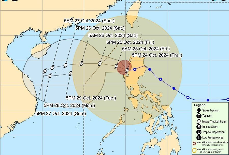
Tropical Storm Verbena (Koto) intensified to maximum sustained winds of 75 km/h before making its seventh landfall in Linapacan, Palawan, at 10:50 p.m. on Tuesday, November 25. Following the landfall, the storm began moving northwest over the West Philippine Sea at 25 km/h.
Prior landfalls of Verbena, when classified as a tropical depression, occurred in several areas on November 24 and 25, including Bayabas (Surigao del Sur), Jagna (Bohol), Talisay City (Cebu), Vallehermoso (Negros Oriental), San Lorenzo (Guimaras), and Miagao (Iloilo).
As of 1 a.m. on Wednesday, November 26, the storm was already offshore and expected to pass north of the Kalayaan Islands later in the evening. The Philippine Atmospheric, Geophysical, and Astronomical Services Administration (PAGASA) forecasts that Verbena may strengthen into a severe tropical storm before leaving the Philippine Area of Responsibility (PAR), which is likely to occur by Thursday morning, November 27.
PAGASA warned that moderate to intense rainfall persists across parts of Southern Luzon, especially in Occidental Mindoro, Oriental Mindoro, and Palawan, where rainfall amounts range from 100 to 200 millimeters. Other provinces such as Quezon, Marinduque, Romblon, and Camarines Sur are also experiencing moderate to heavy rain.
Several areas remain under tropical cyclone wind signals as of early Wednesday, with Signal No. 2 indicating gale-force winds (62 to 88 km/h) in the Calamian Islands and northern Palawan mainland municipalities such as El Nido and Taytay. Signal No. 1, representing strong winds (39 to 61 km/h), covers provinces including Occidental and Oriental Mindoro, Romblon, Palawan, Antique, and parts of Aklan.
In addition to the tropical storm, the northeast monsoon (amihan) has contributed to gusty conditions affecting large portions of Luzon and western Visayas provinces. This combination has led to hazardous sea conditions, with waves reaching up to 6 meters in height in areas like Batanes and the Babuyan Islands, posing risks for all vessels.
Verena is the 22nd tropical cyclone of the 2025 season in the Philippines and the third to form in November, following Typhoon Tino (Kalmaegi) and Super Typhoon Uwan (Fung-wong).
Meanwhile, significant rainfall associated with the shear line—a convergence zone of cold northeast monsoon winds and warm easterlies from the Pacific—is now mostly confined to Northern Luzon. Heavy to intense rain is expected in provinces such as Apayao, Cagayan, and Isabela through Friday.
Authorities continue to monitor the storm and weather conditions closely, urging residents in affected areas to take precautions against flooding, landslides, and strong winds.
"Residents are advised to stay alert for updates as Tropical Storm Verbena moves away from the region but continues to bring adverse weather conditions," the PAGASA bulletin said.
Recommended For You

Ombudsman Targets Lawmakers Alleged to Operate as "Shadow Contractors" in Flood Control Projects
Jan 24, 2026
Filemon Cruzado

Megawide Raises P3 Billion Through Oversubscribed Series 7 Preferred Shares Offering
Jan 24, 2026
Filemon Cruzado

Four Danish Patients Receive Compensation Over Vision Loss Linked to Novo Nordisk Drugs
Jan 24, 2026
Bonifacio Tumang

Tarlac Province Honored for Excellence in Human Resource Management
Jan 24, 2026
Fortunato Guevarra
